I'm one of the cheerleaders out there that has been doing a lot of retrieves this season. Safety has been a priority for me and many other cheerleaders I'vs spoken with at launch. I've tried and researched a lot of the tech to keep myself calm knowing he's safe on those flights over glaciers and back country. We've finally come up with a good combination for maximum convenience and safety with minimum cost and effort:
- Online live tracking with mobile apps. Bonus: use a bluetooth enabled vario.
- Retrieval using Glympse.
- A power bank to charge the phone after long trips.
- ResQLink PLB in the cockpit - NOT SPOT!!!
Live flight trackers
There is a mobile revolution in live flight trackers! Best of all, many of them are free! They have let me celebrate when Eirik is having a spectacular trip, see when he's landed early, and helped me plan the retrieve. For watching the flight in action, my short list includes LiveTrack24, airtribune, FlySkyHy (iOS) and Norway's own GPSDump (Android). These apps use the phone's GPS to upload coordinates every 10s.Better yet, many of the new varios are bluetooth enabled. This means the phone can upload the vario's GPS data instead, which saves phone battery power and improves location accuracy. Eirik has the Oudie 4, which uses it's own app to connect and upload live tracks to several different tracking sites.
Retrieval
For retrieves, my personal favorite app is BBM with the Glympse feature. This is a messaging app like Whatsapp, but has some unique features. Glypse is a lot like the Whatsapp location feature, except that it gives live updates and also shows where I am on the same map. I can see which path he's hiking along and he can see how close I'm getting. I can even add multiple people to the chat and see them all on the same map.Of course, phone battery is a concern after a long flight, so an extra power bank is a requirement for any retrieve.
Satellite messengers are not reliable emergency systems
Live tracking on mobile is a great safety measure - it's easy to check if everything is okay, and if something goes wrong I know exactly where it happened. However, when it stops working I still need to know he's safe. Some of the issues I've had include drained battery (signal just stopped sending at 20%) with almost no power on landing to call for retrieve, losing cell signal (I thought it was his battery again so he had to hike for two hours before getting cell signal), using up all my data by refreshing the track too often, and the website (airtribune) crashing so I couldn't load anything. Mobile is great while it's working, but there needs to be a backup plan.The first idea it seems most pilots have is to get a satellite messenger since it works in places where cell coverage doesn't. Devices like the Spot 3 and DeLorne's InReach send GPS coordinates via satellite, as well as sending "I'm OK" messages to phones and SOS calls to rescuers. Cost for Spot 3 is about kr2300, with a basic subscription fee of 130kr per month. InReach is nearly double that for both the device and the subscription, though the messaging options, coverage, and signal quality are better. Sounds worth the cost, right? The catch is that these devices often don't connect to the satellites when needed most, and when it can't connect it's as useless as a dead phone. I'm going to get technical to explain this, so be prepared to geek out a little.
 |
| GlobalStar (Spot) coverage |
 |
| Iridium (DeLorne) coverage |
Both GlobalStar (Spot) Iridium (DeLorne) are commercial systems and operate on similar frequencies (1610- 1626 MHz range). The broadcast power is low and limited by radio laws. This frequency may not connect to the satellites since the signal is absorbed by thick cloud cover and dense forest and it reflects poorly off buildings and mountains. GlobalStar (Spot) does not have global coverage, for example neither the Himalayas nor Africa is covered, and Norway has a "weak signal". Also, each satellite has a small footprint so it may take several minutes for your orbiting satellite to make contact with a receiving station, delaying emergency response time. On top of that, both companies have gone through bankruptcies and both satellite systems have lost satellites through collisions with other satellites, and reputations are tarnished.
Personal Locator Beacons are military grade SOS
The ultimate emergency solution is a Personal Locator Beacon (PLB). This is hardcore lifesaving equipment and everyone that goes out of cell range should have one. Register it, and keep it somewhere easy to reach like your cockpit. It doesn't live track, but there is no question that rescue will find you anywhere with minimum delay. Key features that make rescue even faster include:
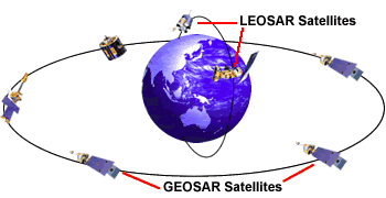 The COSPAS-SARSAT network is an international satellite network dedicated to Search and Rescue. The regulated 406MHz frequency is for distress signals only and is monitored directly by government emergency services such as Norway's hovedretningssentralen. This 406MHz frequency can penetrate thick cloud cover and dense trees.
The satellite network has global coverage and includes low earth orbits (LEOSAR), geosynchronous (GEOSAR) orbits, and the brand new medium earth orbit (MEOSAR) for even faster homing time. The satellite system has two additional unique features that improves response time :
When activating a Personal Locator Beacon (PLB), two notifications are issued immediately. One notification is sent to the country where the PLB is activated so they can begin the search and rescue preparations, and the other notification is sent to the country where the PLB is registered so they can look up who you are. Registration is critical for rapid response as it tells rescuers who they are looking for, what type of sport you're doing, who you are with, and your emergency contacts that can give them more information. Activation of unregistered beacons are treated as emergencies, though you may be fined after a rescue or even pay the full cost of the operation for an accidental activation.
- GPS coordinates for homing in to 100m
- low power homing signal at 121.5 MHz
- strobe light
I have a ResQLink+ that I bought in Canada. There are very few PLB suppliers for civilians in Norway and selection is limited with a cost in the range of 4000kr (vs $250 in US). While battery replacement costs about $150 every 5-6 years, there are no subscription fees. This is a non-profit international emergency service and it is totally free. That being said, Norway is special and charges an administration fee of 450kr/yr (Norsk / English) and is only available to Norwegians. However, country regulations differ and PLBs can be bought or coded for counties with free online registration such as Canada, USA, UK, Sweden where there is also more PLB selection.
Now it's time to geek out again and explain why this satellite system is amazing.
The COSPAS-SARSAT network is an international satellite network dedicated to Search and Rescue. The regulated 406MHz frequency is for distress signals only and is monitored directly by government emergency services such as Norway's hovedretningssentralen. This 406MHz frequency can penetrate thick cloud cover and dense trees.The satellite network has global coverage and includes low earth orbits (LEOSAR), geosynchronous (GEOSAR) orbits, and the brand new medium earth orbit (MEOSAR) for even faster homing time. The satellite system has two additional unique features that improves response time :
- instantaneous relay of alerts to land units from the GEOSAR sats, and
- redundant signal processing to home in on the position (complements GPS).
When activating a Personal Locator Beacon (PLB), two notifications are issued immediately. One notification is sent to the country where the PLB is activated so they can begin the search and rescue preparations, and the other notification is sent to the country where the PLB is registered so they can look up who you are. Registration is critical for rapid response as it tells rescuers who they are looking for, what type of sport you're doing, who you are with, and your emergency contacts that can give them more information. Activation of unregistered beacons are treated as emergencies, though you may be fined after a rescue or even pay the full cost of the operation for an accidental activation.